
Make the McKenzie Connection!
Make the McKenzie Connection!
Continued From Last Week
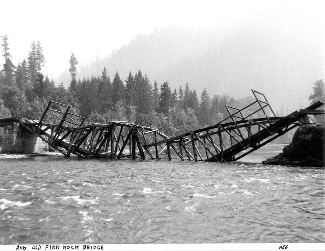
The second "Old Finn Rock Bridge."
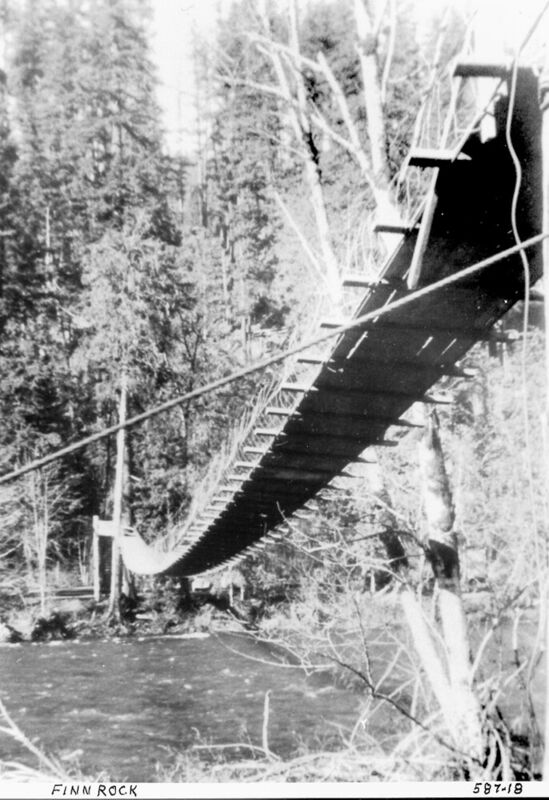
The Finn Rock Swinging Bridge.
Reprinted from McKenzie River Reflections August 27, 1982, edition
About 1925 a steel bridge was built about 100 yards below the old ferry crossing. When it was finished and the old covered bridge was to be removed, the school was dismissed at Walterville. The teacher and students all walked down to the river and stood on the new bridge and watched while the county road crews dynamited the covered bridge to smithereens. The covered bridge at "The Narrows" had to be removed the same way.
In 1963 the present concrete bridge was built just downstream from the steel bridge, which then was dismantled and removed. About two years later one span of it was rebuilt at Deerhorn Point to replace the flood-damaged wooden bridge there.
Mathias Emmerich operated a ferry at his south bank ranch from shortly after 1900 until somewhere around 1937. The settlers on the south bank in this area had established the Rocky Point School just west of the Emmerich place, where the road now turns up the hill to the homes on Tiki Lane in Shangri-la. It was not a part of the county school system so the county was not receiving any tax money from all the timber and land along the south side of the river in this area. They persuaded the settlers to abandon their Rocky Point School and send the children across the river to the Deerhorn School thereby bringing in more tax revenue to that district.
Part of the agreement was that the county would build a footbridge so the children could cross the river to reach Deerhorn School. Some had already been crossing in a rowboat to reach the school. The footbridge was built at the high rocky bluff just above the Emmerich ferry crossing about 1930 or 1931. It was in use up until about 1950. The Emmerich crossing was at the end of Partridge Lane, which is about a mile or so east of Walterville.
A ferry also operated across the river at Deerhorn Point for many, many years. At one time a Major DeForest owned the Deerhorn Ranch which is now the golf course and Deerhorn Park Housing.
David Stephens and his son, Charles, were contracted to haul some lumber to the ranch. The ranch foreman brought the ferry across to the wagon roadside (north bank) to bring them across the river. He said the ferry was leaking a little so he had the best bail out some water before returning across the river with the load. After bailing water out for some time, he signaled the men to drive the wagonload of lumber on the ferry while he finished bailing the water out. After having done so, Charles called attention to the fact that the boat was settling deeper even though the ferryman was still bailing water out of the boat. The man did not believe it at first but after watching for a few minutes agreed and instructed everyone to help get a load of lumber off the ferry. The north bank was quite steep where the ferry landed so the men all heaved ho on the wagon wheels and helped the team of horses to back the wagon off the ferry, it went under, and sank in several feet of water.
Barney Oldfield later owned the Deerhorn Ranch and operated the ferry there. I believe it was abandoned in the late 1930s also.
Many times at extremely low water time there would not be enough current to push or propel the ferries from one bank to the other. At such times the operator would have to resort to pushing the ferryboat across the river as you would a raft. This happened to Barney Oldfield and he had an embarrassing experience. The water was low and he was forced to pole the ferry across. His team became tired of waiting for him to reach the other bank. Since Barney had not bothered to raise the tailgates on the ferry - the horses decided to "take matters into their own hands," they just walked off the ferry, taking the wagon with them, and left a bewildered Barney and his "slow ferry to the ranch" sitting out in the river.
Doctor Edblom had a bridge built across the river about 100 yards upstream from the ferry landing at Deerhorn Point in 1963. The flood of 1964 undermined the concrete pier on the south end of the bridge and tilted it so badly that the bridge had to be abandoned. This was tragedy number one but before it could be dismantled and removed, a young man from down near Alpine used it to commit suicide.
About 1965 or 1966 the county rebuilt one span of the steel bridge that had served at Hendricks crossing. About 400 yards or so on upriver from the short-lived wooden bridge at Deerhorn Point. This is the bridge that connects Holden Creek Lane with Bridge Street by the golf course and Deerhorn Park.
The old, but short-lived Deerhorn Post Office and the Sanitarium were located just off the north end of this bridge back in about 1910. Some of the buildings are still standing on the site. The Deerhorn ferry also is reported to have broken loose one time and landed on Coney Island off the mouth of the EWEB Walterville Canal.
"Donkeyville" was the name given to a logging settlement on the south bank across the river from "Jim Town," which was named for Uncle" Jim Kennerly, an early settler at what we now know as Leaburg. A ferry crossed the river between these two settlements for many years. Lower Leaburg School was located west of Deerhorn Point and Upper Leaburg School was located where the Greenwood cemetery is now.
Many of the children from Donkeyville crossed on the ferry and walked to Upper Leaburg School. By 1914 Leaburg had its own school or I should say the settlement of Leaburg was established at the present site and the school was held there. The ferry to Donkeyville was down in front of the schoolhouse on the Dale Carlson property. In fact, the Carlson's are still using at least one of the few wood anchor posts for the ferry as a corner post in a fence on the place.
One ferry was dynamited into oblivion and destroyed in the 30s. Another was built to replace it and used for some time, possibly up into the early 40s. It is not certain what the demise of this ferry was. It may have washed away during a flood, or some seem to think it was hauled away on a truck. At any rate, it left its cables along the south bank, about all that's left of Donkeyville today.
One run-away ferry "landed" on the riverbank near Walterville. It is believed this one may have come from Leaburg. It was hauled away but to where?
After leaving the Deerhorn Ranch, Barney Oldfield settled on the south bank again, up near the EWEB Leaburg Dam. He also operated a ferry at this point for several years. The dates of this ferry so far remain unknown to me.
Another early ferry crossing was at the mouth of Indian Creek, giving access to the present Goodpasture property. A swinging bridge also crossed the river just upstream from the ferry landing in the 20s.
The Goodpasture covered bridge was built in 1937, just around the curve of the river below the ferry. It is 165 feet of the main span with approaches of 19 and 23 feet. NOTE: This is only 207 feet of the bridge against the 582 feet built at Hendricks. But still, only 30 years later the price had climbed to more than double Hendricks's cost.
Gate Creek at Vida was named because of a tollgate located there on the old McKenzie wagon road. A.N. Striker, a well-known bridge builder in Lane County, built a covered bridge over this stream in 1903. It was an 80.7-foot span built on the Howe style.
Another Howe-style span was the Blue River covered bridge. L.N. Roney, another popular name in bridge building and repairing, built it in 1909. It had 110 feet of span with 53 and 35 feet of approach. Repair notes in 1916 state that heavy truck traffic was breaking the floor down.
I once heard of a group of young men who were going 'Out on the town one night. They were walking into Blue River dressed in their best bib 'n tucker. In so doing they had to cross through the covered bridge. It being after dark, they little knew what had happened to one of their comrades for an instant when he fell flat on his face. He came up cussing and some farmer's cow came up bawling. She surely didn't appreciate having intruders in her "barn."
The Belknap family, like so many other homesteaders all along the river on the south bank, used a rowboat for years to get out to the wagon road. For most of them, this was their only link with the outside world. A Mr. Thomson, possibly of the Vida area, constructed the original Belknap Bridge in 1880. It was a covered structure that served Delta and King Roads and south bank areas. It was replaced in 1911 by Lane County. The third was erected by Lane County in 1939 and was destroyed in 1964 by the Christmas flood. A large log came floating down the river in the floodwaters and rammed into the bridge, going between some of the timbers. When it stopped drifting, the roof settled toward the bottom of the river, thus twisting the bridge. The force of the water pushing against this log, which in turn acted as a ramrod, literally lifted the bridge from its foundations and away it went down the river. The county built the present covered bridge on the same site shortly after the flood. It was opened for traffic on October 31, 1966. This is probably the last covered bridge to be built in the county or maybe even in the state for that matter.
The first covered bridge at the settlement of McKenzie Bridge was built in 1888. This one was replaced in 1907 when L.N. Roney built another covered bridge with a 120-foot span, with 95 and 29 feet of approach. It was located a short distance downstream from the present bridge and out the back of the present McKenzie Bridge General Store. I believe that the present bridge was built in the early 1930s sometime.
I am sure that I have left out many river crossings in this account and probably some pretty important and interesting ones at that. I have not attempted to include the many, many bridges built for logging but wanted to dwell mainly on those used in traveling up the valley and by the settlers in reaching their homes.


Reader Comments(0)